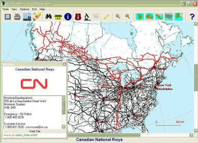
North American Railroad Map for Windows enables users to view or print track maps for North America. Updated with new data from the U.S. DOT and FRA, for U.S. railroads this includes current operator, traffic, signalling, trackage rights, previous operators and passenger use. Shows trackage and operators for Canada and Mexico.
Main features:
-Updated with new data from the U.S. DOT and FRA. For U.S. railroads this includes current operator, traffic, signalling, trackage rights, previous operators and passenger use.
-Shows trackage and operators for Canada and Mexico
-Over 1200 current and past railroads listed
-Display all railroads by class (1-3)
-Locate over 11,000 stations by name, junction code, Zip Code or SPLC code.
-Change station title fonts
-Select multiple (up to 5) railroads with custom colors and line styles
-Toggle individual station titles on/off
-Detail Map - Optional inset map shows greater detail in the U.S.A. based on USGS 1:100,000 maps. (Detail maps are not included for Canada and Mexico)
-Aerial Photos and Topographic maps Online - The program links to Google Maps, Microsoft MSRMaps or TopoZone.com via your web browser and displays an aerial photograph or topo map of the area currently being viewed.
-Calculate approximate mileage for railroads or selected routes.
Comments